G Kameshwar
As I write this series about Kailasa Yatra,
quite a few people have got in touch with questions… “How was it? How tough is it? How does
one prepare? What about the effect of low oxygen?” etc etc…
Net-net, from many, the message seemed to be, “I would love to do it.. But not sure… Perhaps, had I been
younger… But still….”. Recognize the tune?
Well, as a response, let me share a mail that
came to me a few days ago… From a gentleman named KS Ramakrishnan, and this was
our first communication…
He wrote:
“Dear
Kameshwar,
My son in law forwarded your Kailash yatra
blog to me. Very interesting to read the same. I did the yatra in
2011. I was 81 years old then. It was tough especially the
parikrama. We had combined this with a tour of Tibet commencing from
Lhasa. The wilderness of Tibet is breath taking and one can but think of
Kailasanath only all the time. I had also written a travelogue after this
trip. If you are interested, I shall send it to you. God bless you
and yr efforts to propagate our culture and heritage.”
Ab bolo!
Eighty one years old!
I got back in touch with him pronto. I
gratefully accepting his offer of the travelogue of his trip to Mt Kailasa,
which I read with much interest… A humbling, inspiring, educating
account…And with his permission, I am sharing it here.
Here’s the link… Kailash Yatra
2011 – Mr KS Ramakrishnan
Continuing now, from my previous post…
Let’s look at a couple of other ancient
routes to Manasarovar, from Garhwal region of Uttarakhand…
The first one we check out is the one from
Badrinath – via Mana Pass.
Swami Tapovanam, who took this route in 1929,
tells us – “The Puranas say that Lord Krishna and the Pandavas, as well as
several great Rshis, used this pass… There are innumerable traditions and
statements in the Puranas suggesting that it was a common custom for the
great Rshis of ancient India to visit Kailas along this route…”
Here’s a bird’s eye view of the route, shown in red.

As you can see in the map, one needs to proceed
north from Badrinath along Saraswathi river, cross Mana Pass, reach
Tholingamutt in Tibet, and then turn eastwards, to proceed to Mount Kailasa.
This was one of the traditional trade routes between India and Tibet. The path
was closed down by the Chinese in 1951, but reopened for native pilgrims and
traders in 1954. Guess it is impossible to cross except for a few months
in the year… And even during that period, no guarantees.
A slightly more detailed map is given below.
The route marked in Red is the one via Mana Pass, taken by Swami Tapovanam in July 1929….

The journey described by Swami Tapovanam is like this…Mana village is near Badrinath… Near Mana village is the sacred Vyasa Gufa … River Saraswati is nearby.
Swamiji and a group of around seventeen Sadhu-s
went from Badrinath to Keshav Prayag, the confluence of Saraswati and
Alakananda, which is not far from Vyasa Gufa. They then proceeded northward
along the route of Saraswati river. There is no marked road or path… They made
their way across “boulders of
rock and heaps of snow, with only Saraswati river for a guide”…Crossed
streams/tributaries that come in the way (not easy). The progress was very
difficult, labored… At times one could hardly cross a mile in one hour.. Neela
Parvat, the deep blue mountain, came into view. This beautiful mountain is the
mythological abode of Kakabhusunda.
Swamiji’s group took seven days to go from
Badrinath (which is close to 10,000 feet) to somewhere near the Mana Pass
(which is around 18,000 feet). Altitude sickness struck most people… Some
horses perished on the way.. One man too… A few kms short of the top of the
pass, they reached Devasaras (also known as Deotal), a beautiful lake, that was
frozen blue . Swamiji writes – “At
a height of 18,000 feet on the shore of a celestial lake, I entered into deep
Samadhi induced by Nature, forgetting Kailas, forgetting the pilgrimage,
forgetting the world and the body”.
They were forced to spend the night there,
entrusting themselves to the care of the deity of the Pass. A storm, and
chances of survival would have been bleak. Next morning, they ascended again…
After a couple of miles, they came to a pile of stones that represented the
deity of the pass. In gratitude, they made offerings to the deity and accepted them
back as Prasada. Walking on, reaching the top, they crossed over into Tibet.
Descending the pass, they reached the plains by late afternoon that day.
Next day they walked ahead in the great Tibetan
highland plains. On the way, they saw a place which, as per local belief, had
the hoof-marks of the horses that Rama and Lakshmana had used when they came
here. Walking on in the open country, they came across wild horses, deer, and
even a tiger. Fourth day after crossing the pass, they reached Tholingamatam
(Tholing), which lies in the region of the river Sutlej, as it flows from the
vicinity of Manasarovar to the Indian sub-continent. Badrinath to Tholing, a
distance of around 80 miles (130 kms or so), took them 13 days.
This same route is described by the Yogi “M” as
well, in his book, “Apprenticed to a Himalayan Master – A Yogi’s biography”. He
too had a significant spiritual experience at Deotal, on the way. “M” and his
group took 21 days to make the same journey – from Badrinath to Thholingamutt.
He describes the trek as very tough, and mentions that one faced terrible
headaches and nausea due to the lack of oxygen…
More about Tholing Mutt later…
From Tholing, for Mt Kailas, one proceeds east,
south of Sutlej river and north of the Himalaya… Swami Tapovanam walked twenty
miles to Daba, and fifty plus miles more to Gyanima… Mt Kailas was another 40
miles north-east of Gyanima… The route from Tholing to Daba, and then on to
Gyanima and Kailas, was one frequented by highway robbers at that time…
Through such perilous paths did the group of Swami-s tread in their holy
pilgrimage…
The total distance from Tholing to Mt Kailasa
would be around 180 or 190 Kms.
By this route, the pilgrim arrives first at
Kailasa. By the other route from Almora (Kumaon), one arrives first at
Manasarovar. However, this Mana route, a total of around 320 kms or so from
Badrinath to Kailasa, is a longer and tougher route, which has been used since
ancient times…
Swami Tapovanam talks of Mana Pass route in
connection with the kayva (lyric poem) Meghaduta, composed by the great
Sanskrit poet Kalidasa. In that poem, the lover, a Yakhsa who has been exiled
from Kailasa to the middle of India, sends a message to his beloved who is in
Kailasa. He entrusts that message to clouds that are going north, making them
his messenger. Narrating the route that the cloud need to take to Kailasa, the
Yaksha, speaking of the way ahead after reaching Himalaya, asks the cloud to
rise in the Himalaya and cross by way of “Krouncha-Randhra
(Krauncha Pass… A pass in the mountain Krauncha… Krauncha also means the bird
Curlew… And the Crane – see footnote below )… Go by the way of the Swans
(Hamsa-dvara), and soaring beyond, reach the mountain of Kailasa….”
Hamsa, the word for swan, also denotes Ascetics…
Swami Tapovanam says : “Some scholars hold that the Crouncha
Randhra described in ancient poems as the route used by Royal Swans of Lake
Manasa, is the Mana Pass…”…
There are some others who say that the Meghaduta
reference is to another Himalayan pass – another route to Manasarover – which
we shall talk of in the next post…
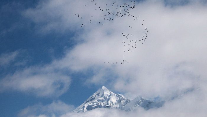
Signing of this post with a short video from youtube, of cranes migrating to India in winter, crossing the Himalaya mountains… Meghaduta comes alive here, with the clouds rising in the Himalaya and confronting the flight of the birds, making them turn back… The cranes return the next day, rise above the world so high, and cross over.
My good friend and co-yatri, Shankar, was the
one who pointed me to the youtube video of the cranes. After reading this post,
he also sent me wikipedia info on Demoiselle crane which says: “The Demoiselle
Crane is known as the Koonj (कूंज, کونج, ਕੂੰਜ) in the
languages of North India and Pakistan…. The name koonj is derived from the
Sanskrit word kraunch, which is a cognate Indo-European term for crane itself.”
Food for thought, regarding Krauncha-randhra….
To be continued...
(The author is a Traveler, Writer, Story Teller, Software Engineer)